Vietnam Hills
| Game Modes | ||||
|---|---|---|---|---|
Contents
Overview
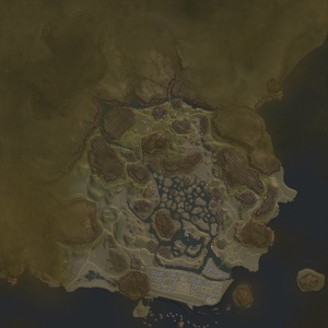
Vietnam Hills or simply Vietnam is a ground forces map available in all modes. It was added in Update 1.85 “Supersonic”. The map is set Vietnam’s central coast, during the Vietnam war.
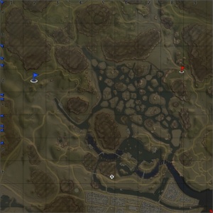
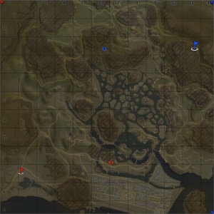
The map has a few distinct areas. The east and west areas of the map (where the spawn points are located) are jungles with winding roads cutting through them. The terrain is uneven, and there are small settlements, temple and ruins dotted throughout the area. Many of the ruins seem to be recreations of the Mỹ Sơn (a collection of abandoned Hindu temples in Vietnam).
The north of the map is home to a number of rocky mountains, with players fighting in the gorges between them. The most eye catching feature in this area of the map is the main valley, running east to west, it has been the victim of a napalm strike. The area consists of uneven and rocky scorched earth, burned trees, and the odd crashed helicopter. Along the norther edge of the map there is a (not completely accurate) recreation of the Po Nagar Cham Towers.
The centre of the map consists of swamplands with many small islands and wooden huts, and a reasonable amount of trees and foliage. In the south of the swamps there are some more substantial islands, connected together with bridges (some of which have been destroyed). These islands contain far less foliage and are more built up with a greater number of larger buildings and various small docks.
The sout of the map is dominated by a large town. It consists mostly of extremely densely packed 2 story buildings. The dominant feature of the town is a massive Opera house. Behind the opera house there is a large temple, as well as two smaller temples in the east and west of the town.
The full tank battles map is 4km x 4km, although that includes an area of water in the southwest and areas in the north / west which are clearly not designed for use in tank battles, reducing the area suitable for tank battles to approximately 2.7km x 2.7km. See the table below for the restricted size available in each game mode. The air battles map is 65km x 65km.
| Game Mode | AB | RB | SB |
|---|---|---|---|
| Domination | 1.9 km x 1.9 km | 2.4 km x 2.4 km | 2.4 km x 2.4 km |
| Conquest #1 | 1.9 km x 1.9 km | 1.9 km x 1.9 km | 1.9 km x 1.9 km |
| Conquest #2 | 1.9 km x 1.9 km | 2.4 km x 2.4 km | 2.4 km x 2.4 km |
| Conquest #3 | 1.9 km x 1.9 km | 1.9 km x 1.9 km | 1.9 km x 1.9 km |
| Battle | 1.9 km x 1.9 km | 2.4 km x 2.4 km | 2.4 km x 2.4 km |
Historical Background
This map is stated by Gaijin to be inspired by the City of Hội An and surround area, located in the South Central Coast region of Vietnam. Although the geography of the map and the town bare resemblance to the area around Hội An, the layout of the map is completely fictional. There are also a number of Vietnam's landmarks (modeled to varying levels of accuracy) included in the map, many of which are located a substantial distance from Hội An in real life. These include:
- Po Nagar - located in the north and east of the map (real location Nha Trang, 256 miles / 412km south of Hội An)
- Mỹ Sơn - located in the east and west of the map (real location 16 miles / 26km west of Hội An)
- Tam Thai Pagoda gate - used as decoration in various areas of the map (real location Thuy Son, 10 miles / 16km north of Hội An)
- Thai Hoa Palace - Located in the southeast of the town (real location Hue, 65 miles / 105km northwest of Hội An)
- Thien Mu Pagoda - Located in a few places around the map (real location Hue, 65 miles / 105km northwest of Hội An)
- Hanoi Opera House - The big opera house in the town (real location Hanoi, 390 miles / 630km northwest of Hội An)
The city of Hội An was home to the Hội An Base Camp, occupied by Republic of Korea Marine Corps and Army of the Republic of Vietnam troops during the Vietnam War. Throughout the war the city of Hội An managed to remain almost completely undamaged.
Map configuration
Domination
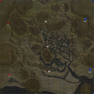
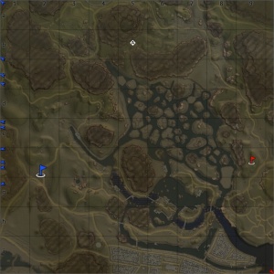
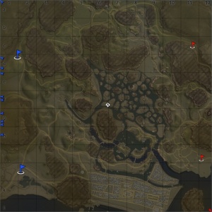
There are three capture points. Point A is located at the base of a tall mountain at the western end of the napalmed valley, point B is located near the western edge of thew swamp, near a small hill, and point C is located on the western tip of the large island, just north of the town.
Conquest
There are three configurations of the conquest mode, each with one capture point. The point will be in one of the locations that appear in domination mode.
Battle
There are two capture points, each owned by one of the teams. The capture points are located in the same places as the A and C capture points from the domination game mode; player spawns are in the northeast and southwest.
Strategy
Media
References
Read also
Sources
Paste links to sources and external resources, such as:
- topic on the official game forum;
- other literature.


